On Winter’s Edge
As the nights turn colder and the days grow shorter, we close the windows to fall and brace for winter. The northern sky slowly tilts away as the sun sinks lower in the horizon. The winds grow stronger. Delivering arctic blasts in waves, which wage war against the global furnace of Earth.
Changing temperatures across Earth’s oceans spawn forecasts (from NOAA) that project a “warmer than normal” season once again while the jet stream begins to buckle, showing signs of cold. Now, on the edge of winter a change is upon us. The Canadian snow pack builds with arctic air awaiting the signal to head south. Might this be the long awaited return of winter?
The Current View (Mid-November)
Since the first of October, rain had become scarce with a mere inch and a half of it recorded (through mid-November). A departure that exceeded 50% of normal for that time of year. In spite of the muddy days of this past winter and spring, the days of fall had become cursed with drought, driving the threat of wildfires across much of the Northeast.
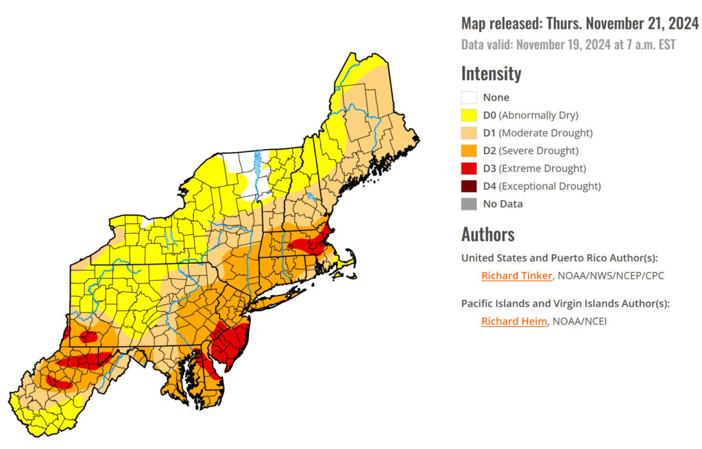
Many towns and states called in burn bans as Red Flag Warnings were issued by the National Weather Service with hot spots visible on satellite in the Poconos and Berkshire Mountains. The most notable, the Jennings Creek Fire, near the NY/NJ border managed to stay alive for 14 days and scorched over 5,000 acres of land despite the efforts of over 400 fire companies and 500,000 gallons of water (according to Mid Hudson News). Now with the help of Mother Nature, wildfire season in the East has been put to rest as waves of weather march in with the approach of Thanksgiving.
A White Thanksgiving
November rains eventually returned as the storm track shifted east. Even the season’s first snow was logged on November 21st bringing inches to feet of the white stuff across Pennsylvania, southern New York, and northern New Jersey. But it wasn’t without cost as tens of thousands suffered through chilly nights without power as the heavy, wet snow brought down trees, powerlines, and rendered substations inoperable.
These early snows often carry a huge set of challenges as plows hit the road for the first time since the close of last winter. Snow removal providers rush to dust off their equipment and prep for their first runs as weather forecasters shake off the early season jitters. Elevation plays its usual trick allowing the snow to pile while folks in the valleys stare in confusion by all the fuss.
This storm was no different as forecasts stretched from none to a ton. One town, Pike Township, located in Bradford County experienced a wide range of snow from 4 inches to 13 according to township supervisor Casey McPherson. “Some roads didn’t even require the plow while others took multiple passes to clear.”
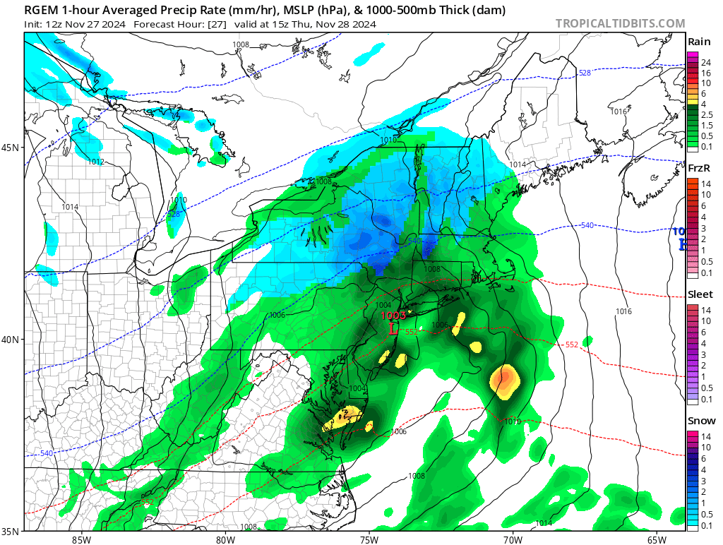
Now that we’ve had time to recover and turn the lights back on, folks are already prepping for the next storm as the busy holiday season approaches. It’s not often that the Northeast sees a white Thanksgiving. According to a Fox Weather article. “Most of the Northeast and Midwest have only a 10% to 30% chance of snow on Turkey Day each year”. Well this time, odds are in our favor as weather models depict a band of snow overnight into Thanksgiving Day with as much as a four to five inches possible in the elevations of the Twin Tiers. Thankfully for this go around, the power should stay on in most areas, allowing little disruption in the kitchen as the turkey and stuffing hit the oven.
The December Chills
Once we sleep off the calories from Thanksgiving, we will awake to the chill of a winter wind. The chance of snow will come and go as bands fly in from the Lakes and clipper systems pass in the breeze.
A December cold not often seen will be unleashed as arctic air rides in on a conveyer belt from Canada. Temperatures may struggle at times to get north of freezing for the first 10 – 12 days as wind chills in the teens and single digits drive the message home that winter has arrived. Will we then see some relief as we reach the mid-point of the month or will this frozen sleigh ride continue all the way to Christmas?
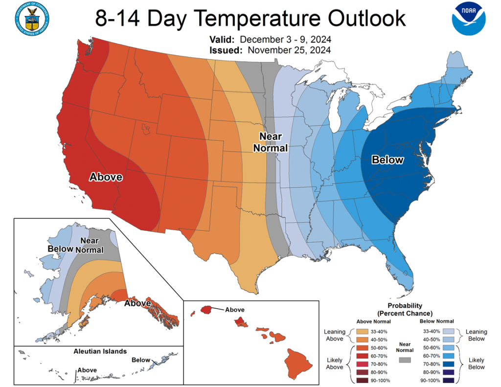
This changing pattern being fueled by the flexing of the jet stream and high latitude blocking could very well continue to bring increased storminess to the East Coast this winter, according to National Weather Service Meteorologist Jim Sullivan. With more frequent visits of these polar airmasses, this “blocking” pattern may be of common occurrence, and we’re already witnessing it.
Digging Back
As we compare winters past in search of a common theme, one thing remains true, no two winters are perfectly alike. Regardless, it remains a common practice to compare like years (or analogs) to assist in the long-range projection of an upcoming season or year.
Digging back we find a couple of years that carry the theme of this coming winter (a neutral to weak La Niña): 2020-’21, 2016-’17, and 2013-’14. These analogs suggest that there is a good chance this winter won’t be “cold” the entire way through with mild spells sprinkled in between. They also carry the idea that there may be plenty more snow yet to come. Perhaps more than normal.
2016 – 2017 was a very active winter despite the frequent warm-ups, and ended up as the snowiest on record at the Greater Binghamton Airport in NY at a whopping 134.2″. While it’s not to say that we will follow directly in those footsteps, it is worth noting that the prior winter (of 2015 – ’16) was a Super El Niño (similar to our last winter, a Strong El Niño). Now we find ourselves on a cooling trend in the equatorial Pacific Ocean just like in 2016 – 2017 and forecasters project that a weak La Niña is ahead. (What is La Niña? Click here to learn more.)
Another good pattern indicator outside of El Niño and La Niña is the Pacific Decadal Oscillation, or PDO. Like the El Niño Southern Oscillation, the PDO shows a relationship to climate with the changing temperatures across a large body of the Pacific Ocean. Only instead of the central Pacific, PDO focus in the northern Pacific. We also have a negative or positive phase, which slowly changes over the course of years or even decades.
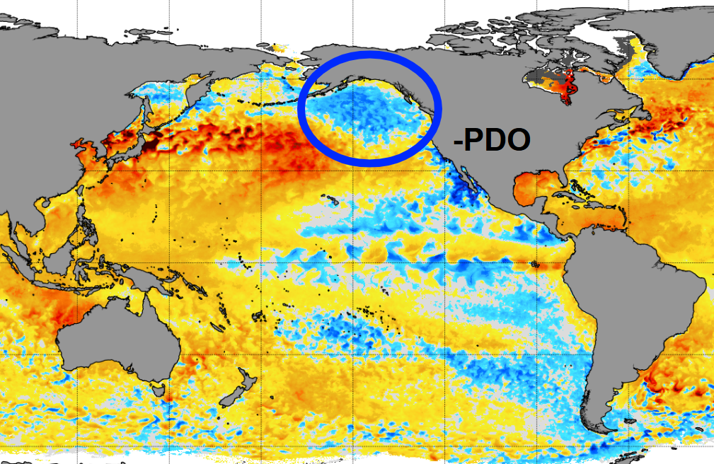
During the past several years the PDO has been in a negative phase, which indicates cooler waters south of Alaska (as seen in the image above). This often leads to low pressure and cooler conditions in the West while mild weather surges in the East. This negative PDO has likely been a contributor to our mild winters over these last three years. And while it still may suggest that a mild winter is in store, this pool of cold water has begun to shrink. Could this be a sign of the change ahead?
The Final Call
Despite all the indicators we’ve discussed thus far, there are still other passengers in the car that could take the wheel and steer this winter in a whole new direction. Long range weather patterns, while a great first look into how the dominos might fall, could easily be swayed by shifts in blocking or surface high pressure building into the wrong place.
The going forecast by NOAA’s Climate Prediction Center calls for above normal temperatures to be favored across the Eastern U.S., which can be argued in support of the analogs and the negative PDO that we’ve discussed. Meteorologist Jim Sullivan projects that temperatures could end up as much as 1 to 3°C above normal from central PA to southern Upstate NY this winter. That said, a few big storms may certainly make up for those milder spells with the high terrain cashing in.
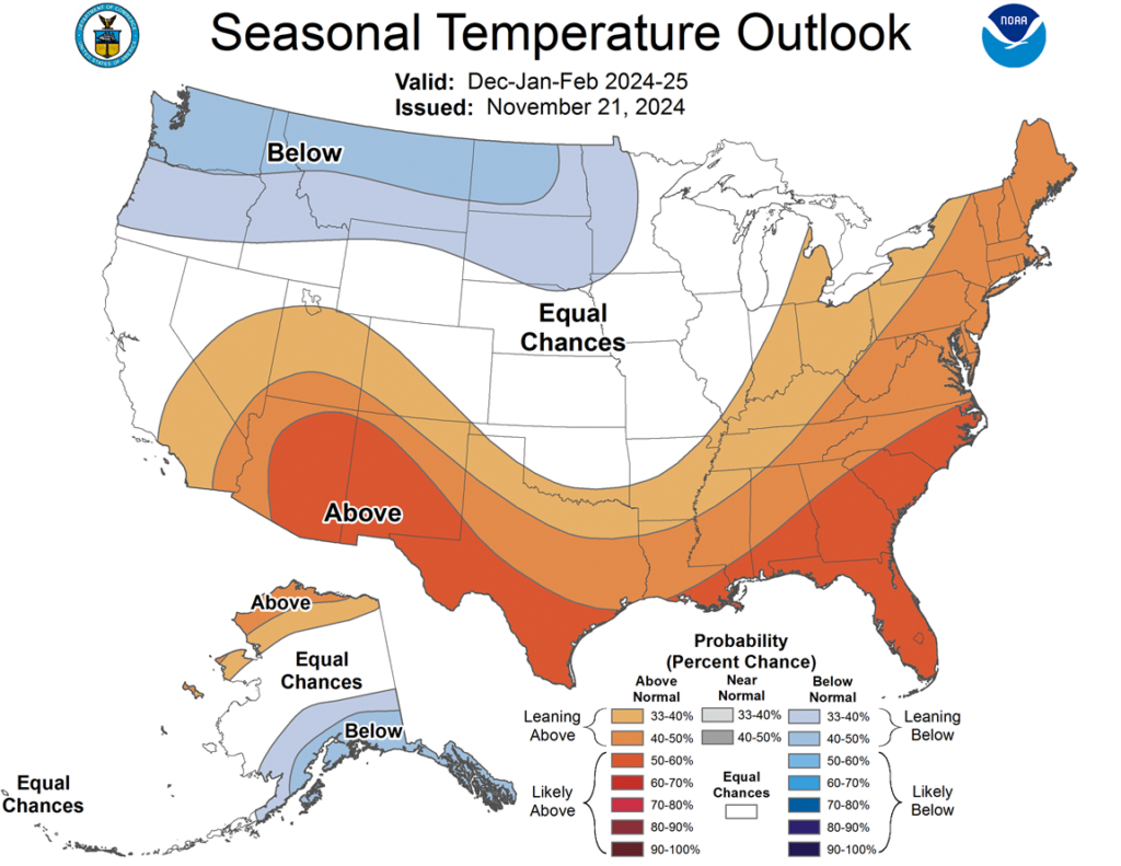
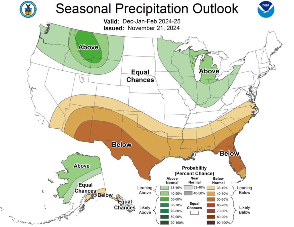
Down towards State College and into Stroudsburg, Pennsylvania, the winter snows may be less frequent as marginal temperatures support the chance to mix with rain. Their season’s total may come in just shy of average despite the potential for an active season.
As you climb up the Pocono Mountains and repel down into the Wyoming Valley, both areas may be at better odds to see an average snowfall, with some towns ending up just above normal. With a foot of snow already under their belt from last week’s storm, these areas are already off to a good start.
Continuing into the northern tier of Pennsylvania and the southern tier of New York, more frequent events including lake effect snow and clipper systems will likely bring the season’s total to amounts that haven’t been seen over the last three winters. While the river valleys may fall short at times, an average snowfall seems every bit achievable.

Very interesting, thank you