Droughting The Snow
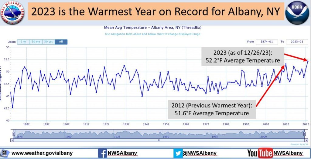
Mother Nature’s mood swings have left us all feeling a bit uneasy as we decide which season to dress for each morning. December had us primed for Spring with monthly average temperatures of 6 – 8°F above normal as we closed the books on one of our warmest years on record. For many in the Northeast, 2023 was even among the top-10 wettest years in the last 150.
It’s not so unusual in today’s climate for a couple quiet winters to pass before the big one hits, but some red flags are thrown when places like Central Park in New York records their least amount of snow since records began in 1869. In fact, much of the East remains stuck in a snow drought as we continue to lose any site of snow to the falling rain.
Cities like Philadelphia are questioning whether they will get their turn as almost two full years have come and gone without an inch of snow to call their own; their last inch or more of snow was recorded back on January 29th, 2022 when they saw just over 5.0″. So as this snowless streak continues, might there be an end in sight or will Mother Nature continue to rain on their parade?
Tipping the Scale
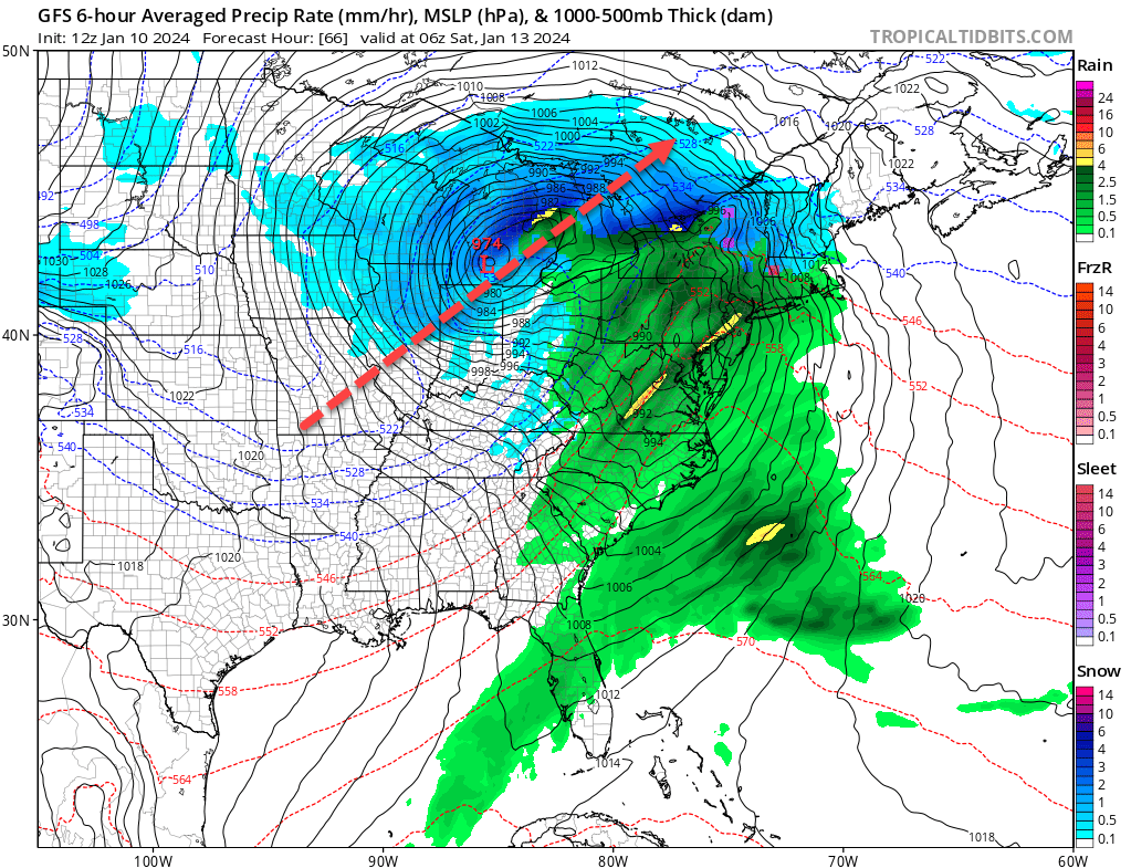
For much of the season, cold air has been non-existent in this part of the globe, confined to the North Pole and Siberia with little cross polar interaction due to the split circulation of the Polar Vortex. Well a recent change in the upper-level pattern has allowed artic air to make its way across into North America and is already tracking across the Great Plains as the next major weather system moves into the Northeast.
Parts of the Upper Midwest are bracing for what may be their biggest snow of the season with blizzard-like conditions and nearly a foot of snow for the windy city of Chicago. Unfortunately, a storm track like this doesn’t always favor big snow in the Northeast as the center of the low tracks across the Upper Great Lakes in what is known as a ‘Great Lakes Cutter’. Often times, Pennsylvania and New York end up on the warm side of the system, eventually changing any wintry precipitation over to rain.
Tapping into the Arctic
This storm has opened the flood gates to a push of arctic air that will swarm the Central U.S. with temperatures of -30°F to -15°F across the Northern Plains. Combine that with a 15 to 25 mph sustained wind and we’re talking wind chills as cold as -60°F in some areas! Here in the Northeast temperatures won’t be quite that extreme, but we’ll certainly see our coldest days of the season.
Following the passage of an arctic cold front early Saturday, temperatures in western PA & western NY will fall below freezing during the morning hours in what would be considered a “flash freeze”. For the Twin Tiers and into the Poconos, sub-freezing temperatures look to cross our area during the afternoon and evening hours Saturday. Through the remainder of the weekend temperatures won’t return above freezing and might even stay below <32°F for the next 10 days.
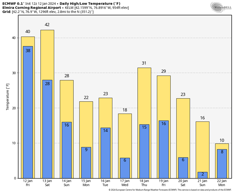
Coldest conditions look to focus during the front half of next week with overnight lows in the single digits. Wind chills won’t play too much of a factor once high pressure builds in after this weekends 40 mph winds, but a secondary surge of cold air behind the next arctic wave late next week could certainly crank up those winds again.
So how about the snow? Well now that it’s cold enough, there’s certainly a better chance for us to rebuild our snow pack, but often times when it gets this cold most of the larger weather systems get suppressed to the south. That said, there is a potential for a period of snow on Tuesday should our cards play out, and if not, another window exists between the 18th-20th of January to turn one of these fast-moving waves into something more.
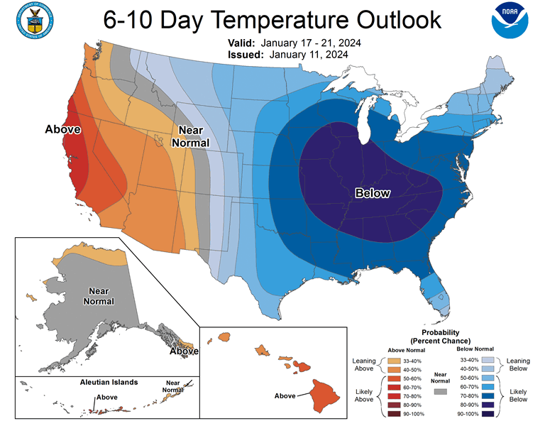
This deep freeze was bound to happen sooner or later, but now forecasters from the Climate Prediction Center (CPC) are doing a 180 as their warmer than normal January is starting to bite back. Some trends beyond the 10 days period begin to show an ease on this cold arctic air; however a few models are loaded with another reinforcing shot from the Polar Vortex, which may focus just north of us into eastern Canada later in the month. Perhaps all this arctic activity will spark a big storm or two in the East before we turn the calendar to February. For now, the forecast is looking rather bleak with bitter cold and near to below average snowfall.