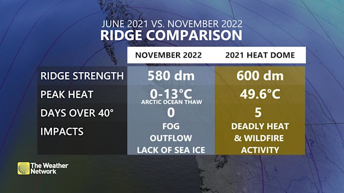
Mid-November Cold
The jet stream was shaken from its slumber following some big hits as the remnants of Hurricane Martin and Hurricane Nicole were pulled into the Northern Atlantic earlier this month, disrupting the pattern over the Arctic. Since then, high pressure has been ballooning across the western U.S. / Canada and is on its way to breaking a recent record that was set back in June of 2021.
Surface high pressure (in excess of 1050mb) sliding down the leeward side of the Canadian Rockies will inject an anomalous cold airmass into the central and eastern U.S. through the upcoming weekend. Temperatures look to track below normal across the Northeast from the 17th – 21st with low temperatures falling into the teens to lower 20’s F and daytime highs only in the 30’s F. Average highs for this time of year usually sit in the low-mid 40’s F.
Monstrous Lake Effect Snow
All the buzz surrounding this incoming cold spell is the crippling lake effect snow that will impact areas downwind of Lake Erie and Lake Ontario. For the Twin Tiers, this won’t amount to much… just a round or two of snow showers and squalls, some of which could lead to quick accumulations of no more than an inch or two, especially towards the Finger Lakes. But if you’re heading out for the Bills game this weekend, you may want to think twice.
The National Weather Service office in Buffalo, NY is calling for up to 3-5 feet of snow in the Buffalo Southtowns with around 2 feet in Watertown. Other providers are claiming even more could fall, which would easily rival the “Snowvember” lake-effect event that dropped nearly 7 feet of the white stuff in western NY between November 17th and 21st, 2014. Oddly enough, this is nearly the same dates as this upcoming event, only eight years later… The NWS office provided a post-storm recap of what many described as the “wall of snow” that left thousands of motorists stranded in their vehicles, triggered widespread power outages, structure collapses, and killed over a dozen people.
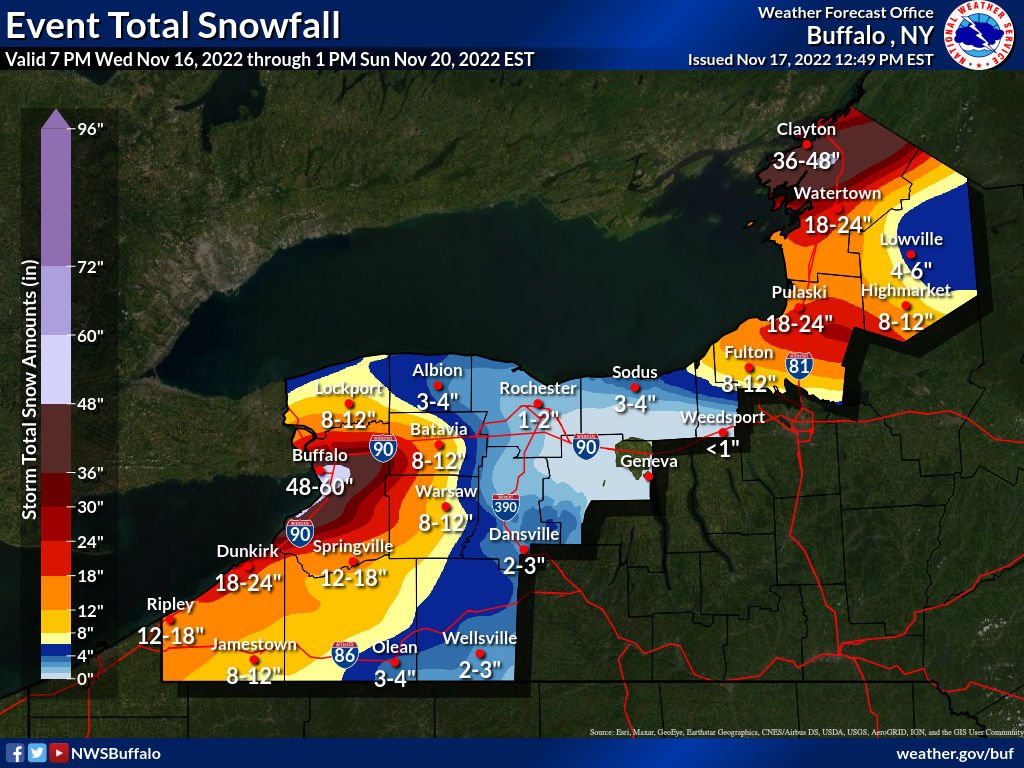
In hopes to prevent a repeat of 2014, the New York governor has declared a State of Emergency, announcing that the New York State Thruway will be closed to commercial traffic from Rochester to the Pennsylvania border beginning 4PM EST Thursday. Already parts of northwest PA and southwest NY have received over a foot of snow and the main event has yet to begin.
Thanksgiving Forecast
Following this stretch of wild weather, temperatures are expected to navigate back towards average as we head through the first half of next week (following a cold start to Monday). High pressure looks to dominate over the central mid-Atlantic, which will provide us with a bit more sunshine each day and highs back in the 40’s F. Still, some chilly nights in the mid-upper 20’s F are expected given the calm and mostly clear conditions.
Sadly, this sense of normalcy doesn’t last long as model guidance is hinting at another cold plunge for the Thanksgiving holiday and the return of below normal temperatures. Just how cold it will get remains to be seen as weather models have a tendency to over-do the magnitude of cold air in the long range. That said, we may just need an extra day to defrost the turkey as high temperatures could struggle to get out of the upper 20’s to low 30’s F for the holiday despite dry conditions and partly sunny skies.
So what is supporting this sprout of January-like conditions yet again? A teleconnection (fancy word for large-scale pattern) called the Eastern Pacific Oscillation (EPO). This wave pattern will make an attempt to dip towards the negative phase for Thanksgiving, which indicates that an area low pressure will be present across the eastern half of North America.
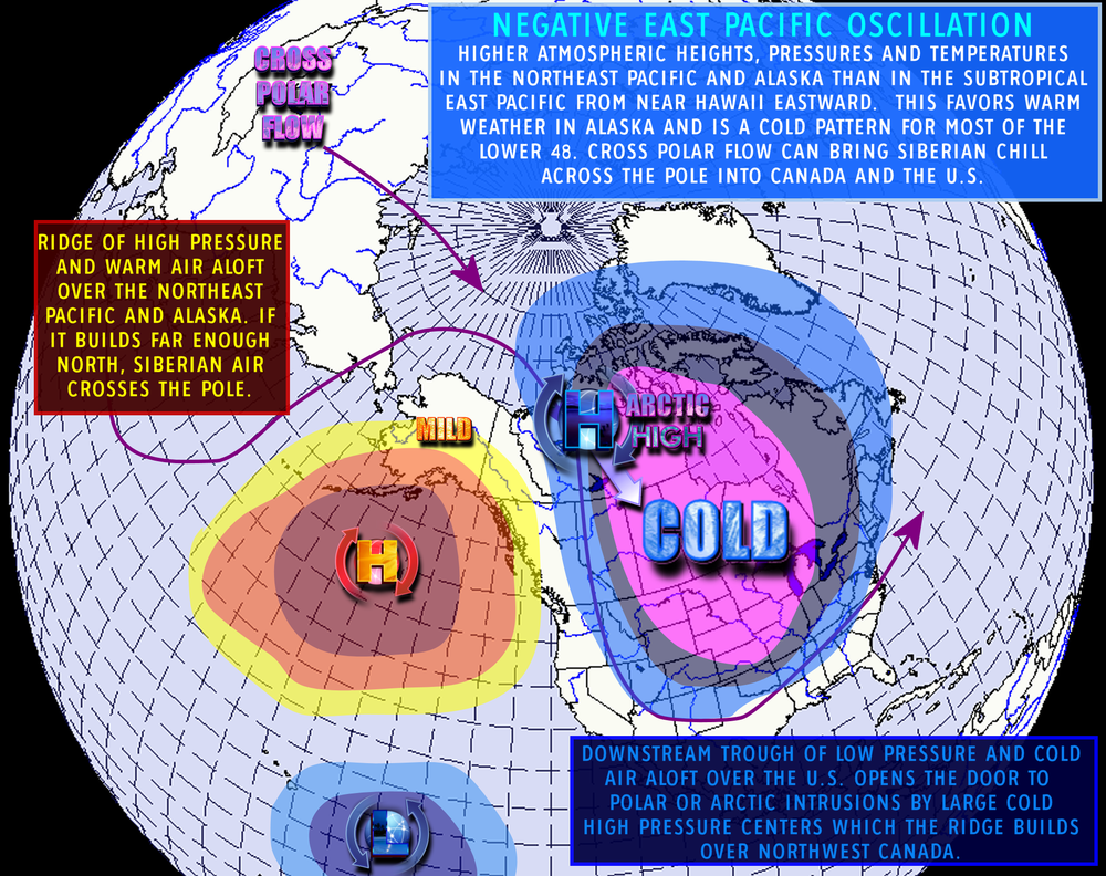
An extreme negative anomaly of the EPO is setting the stage for the cold air outbreak this coming weekend. Thankfully, Thanksgiving won’t be quite to this extreme as it falls in the weak-negative to neutral phase of the EPO. That said, a shift off to the east of it’s normal position may offer an interesting twist to the setup as high-latitude blocking moves into the Northern Atlantic, closer to Greenland.
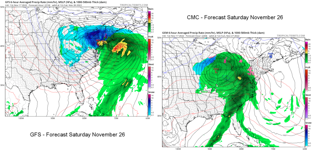
Generally when we see these types of set-ups they mean business, and for this time of year that could either be big snow or a wintry mix to all rain. Both in fact, are potential options at this point for Black Friday and into the holiday weekend. Although it’s still too early to call, it certainly brings concern to what is usually a very heavily traveled weekend.
A quick look towards December
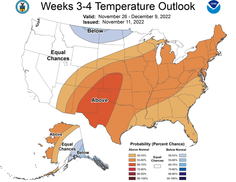
Following the departure of this low pressure system, cold air will be ushered back into place across the Midwest and Northeast leaving us with some below normal days as we prepare to turn the calendar. What was an active pattern that filled the month of November may try to level off for the first few days of December, perhaps offering a brief trip back to normal temperatures. To support this claim, The Climate Prediction Center (CPC) released their forecast last week for this time frame and are predicting the possibility of above average temperatures across the eastern U.S. into the start of the month.
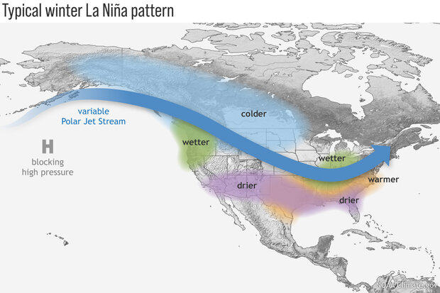
From there, the pattern turns a little fuzzy as we must rely on the long-range predictors like teleconnections and the El Nino Southern Oscillation (ENSO) to tell us how things might unfold in the far-term. For those that don’t know, we are in the third year of the La Nina pattern (or ‘triple-dip’ La Nina) and it is expected to hold strong through the heart of the winter before heading towards the neutral phase. Something that hasn’t happened since the turn of the century… This alone is a decent indicator that the Northeast may see more mixed events and above normal temperatures at times throughout the winter; however, no two La Nina’s are built quite the same.
In the month-to-month term we rely on the teleconnections, which there are several of and many different models out there to predict them. Looking at the EPO, some global models are pushing things into the positive phase as we head into December, suggesting milder Pacific air across the Lower 48. Other indicators like the Arctic Oscillation (AO) and the North Atlantic Oscillation (NAO) also are forecast to be in the positive phases through the first half of the month, which both support the claim for warmer than average temperatures on the east coast.
These indicators, however, aren’t fool proof and are merely a guidance to the overall pattern. Small perturbations tend to be averaged out and can’t necessarily be depicted on a small scale this far out. Thankfully for snow lovers it does look like these patterns might break down during the second half of December, which may give us a shot at a white Christmas (it’s been a while) and perhaps a chance to hit the slopes as we head into 2023.
Pingback: Are Big Changes Coming for December? - Wiles Valley Weather