Staking Their Claim
Every September some of the nation’s most respected climate scientists issue their first long range outlook for the coming winter season, highlighting potential areas of above or below normal temperature & precipitation across the continental U.S.. While one might think that a prediction this early in the season would be about as good as flipping a coin, numerous factors are taken into account that affect the global pattern including the most recognized, El Niño–Southern Oscillation (ENSO).
Climate scientists, or climatologists, have long been trying to perfect the method of long range forecasting to better help us prepare for global events like hurricanes, heat waves, and droughts by way of seasonal comparisons and global pattern recognition, but much of the trouble comes from the limited window in which we’ve had satellites and other measuring networks strategically positioned across the Earth. Sure, we can study ancient air bubbles trapped in ice and correlate certain characteristics to the climates back in time, but just in the past two hundred years alone our climate has seen drastic shifts and will always continue to evolve. So how is it that we can claim that this El Niño winter might be similar to winters past when like snowflakes, no two are like.
Super El Niño
On November 9th, 2023 the Climate Prediction Center released an update stating sea surface temperature anomalies across the equatorial (central) Pacific Ocean have increased, indicating that we are now in a strong El Niño, with a 35% chance of this event heading to “historically strong” levels during the November-January period. So why might that matter to us?
Well to quickly sum it up, the El Niño–Southern Oscillation (ENSO) consists of three main phases: Positive (El Niño), Neutral, and Negative (La Niña). The temperatures in the equatorial Pacific Ocean along with the strength of the anomaly determines which phase we are in and can severely influence the overall global pattern. The resulting placement of the Pacific Jet Stream and the strength and direction of the trade winds near the equator all can have an impact the weather conditions here in the Northeast.
Click the video below to learn more about El Niño and La Niña or visit: here
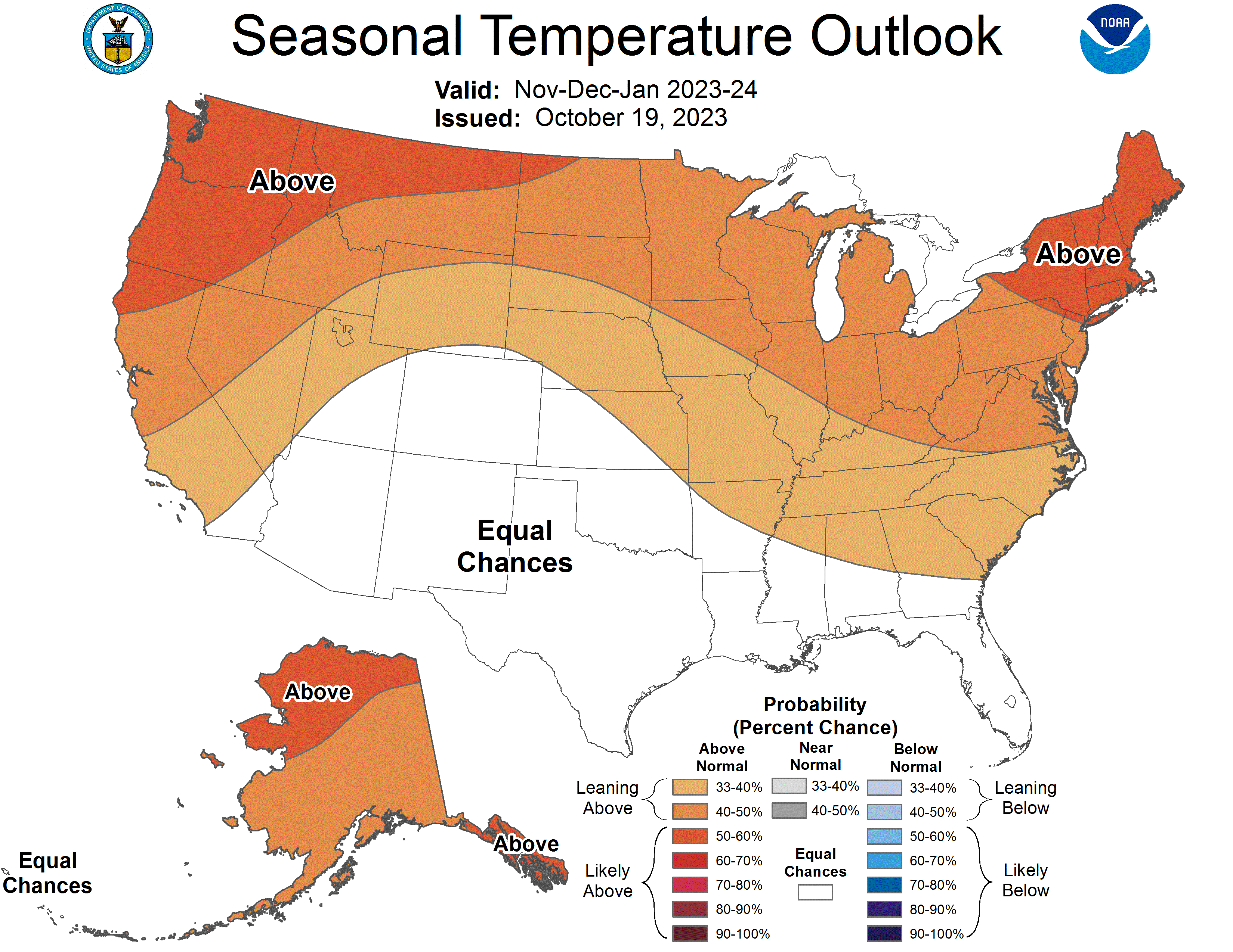
Typically during an El Niño, the Northern U.S. sees warmer than average temperatures through the winter months, pending when the onset of El Niño takes place and it’s strength or magnitude. Given recent trends, this 35% chance for a historically strong or ‘Super El Niño’ now calls into question just how much snow we may or may not see during the upcoming winter season. From the comparison below, we can get a better understanding of what we typically expect in the U.S. during an El Niño versus what is actually being predicted from the experts at the Climate Prediction Center.
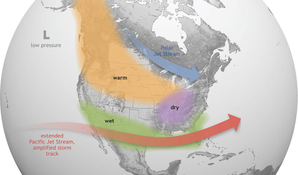
El Niño pattern in North America during winter
Should the central Pacific Ocean continue to warm over the coming months, we will certainly be heading toward territory that is normally uncharted; this potentially being only the fourth Super El Niño recorded in the last 75 years. The others were in 1982-83, 1997-98, and 2015-16, which saw temperatures anywhere from +2.2°C to +2.6°C above normal. (Some consider the 1972-73 El Niño an extreme event as well, which came close at +2.1°C.) The climate model prediction from NCAR (National Center for Atmospheric Research) calls for this year’s numbers to rival those of historical record.
Comparing Years Past
So what exactly happened during the last Super El Niño events and can we find any correlation that might point us towards a prediction for this winter season? Well the tricky part is that no El Niño events are truly alike. This year being unique in that the record temperatures of the Atlantic Ocean and Gulf of Mexico could play a big part in the resulting winter as they did with this year’s Atlantic hurricane season. We also can’t forget that we are coming off of a third year La Niña, which none of the other Super El Niño events were proceeded by – something that also makes this winter truly unique.
Taking these Super El Niño years for face value, we begin to see a pattern similar to that of the seasonal outlooks from the CPC (above). Below we have the average temperature and average precipitation for those specific (Super El Niño) years. It’s evident that the warm anomalies generally hug the northern half of the country; however, the precipitation during these periods falls somewhat near average in the Northeast. Perhaps much of this is due to the commonality or frequency of large weather systems tracking up the East Coast, some of which became Nor’easters.
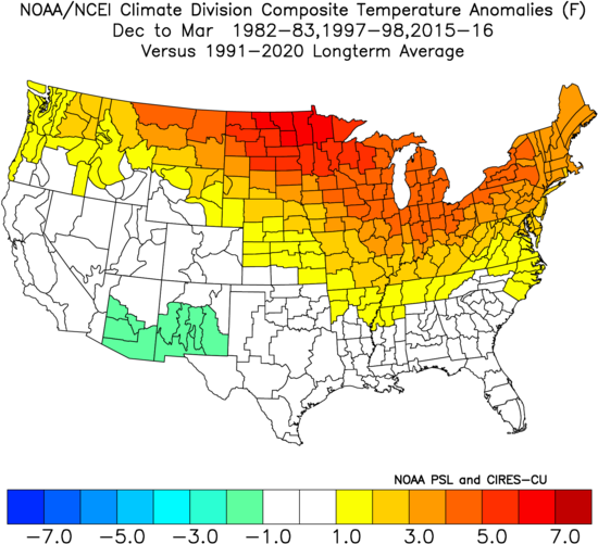
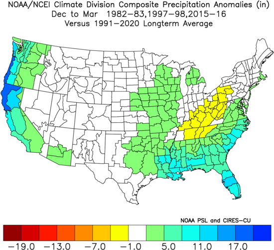
Temperature and Precipitation comparison for December to March of 1982-83, 1997-98, and 2015-16
Comparing the snowfall during these years from a couple select areas in Pennsylvania and New York, we start to see a mixed result of snowfall, perhaps due to some of these storm events falling as rain vs. snow. But nothing stands out more than the 2015-16 season, which showed a clear deficit in snowfall and overall precipitation across the board. It also happened to be our warmest winters on record up to at that point.
| Monthly Total Snowfall for BINGHAMTON (GREATER AP), NY | ||||||||
| Year | Nov | Dec | Jan | Feb | Mar | Apr | May | Season |
| 1982-1983 | 3.2 | 13.3 | 23.2 | 8.6 | 9.1 | 22.9 | 0.2 | 80.5 |
| 1997-1998 | 11.3 | 34.3 | 8.7 | 20.5 | 17.2 | T | T | 92.0 |
| 2015-2016 | 0.8 | 2.2 | 10.2 | 8.2 | 1.0 | 9.3 | T | 31.7 |
| 30-Year Mean | 7.6 | 19.0 | 20.5 | 19.3 | 16.7 | 4.2 | 0.1 | 87.5 |
| Monthly Total Snowfall for STATE COLLEGE, PA | ||||||||
| Year | Nov | Dec | Jan | Feb | Mar | Apr | May | Season |
| 1982-1983 | T | 1.8 | 6.7 | 10.9 | 3.2 | T | 0.0 | 22.6 |
| 1997-1998 | 2.9 | 14.7 | 8.6 | 17.1 | 4.9 | T | 0.0 | 48.2 |
| 2015-2016 | T | T | 9.9 | 6.4 | 0.2 | 1.4 | T | 17.9 |
| 30-Year Mean | 2.5 | 7.7 | 11.3 | 12.0 | 8.6 | 0.9 | T | 43.0 |
Digging into climate records, there is a show of similarities between the strength of the El Niño and the outcome of winter season. For these historically strong events, more times than not, much of the Northeast will end up warmer and wetter than normal with less snow especially the closer you get to Philadelphia and New Jersey. On the contrary, moderate to strong El Niño’s tend to be on the colder side. The way things look now, we may be heading closer to historically strong levels and perhaps a milder winter.
TOO EARLY TO CALL?
Many meteorologists have already staked their claim in the outcome of this winter even though (for some) the season’s first accumulating snowfall may still be weeks away. Far from the Climate Prediction Center’s warm and wet winter forecast, many in the Mid-Atlantic are taking an early stance saying that snow may pile higher than years past. For places like Washington, D.C., our capital city has only received shy of 20.0″ of snowfall collectively over the last three winters. However, the folks down at The Washington Post known at the Capital Weather Gang are calling for the most snow in D.C. in over five years (see their article: here). Their reason to claim is the favorable storm track for “coastal runners” and even Nor’easters (as seen below).

While this storm track is certainly more favorable during El Niño winters, these lows have a tendency to track inland pushing the rain/snow line well past the I-95 Corridor, and in some cases, as far west as I-81. So while we certainly may see heightened storm activity this winter, it will all come down to short-term set ups as cold air may be hard to come by this season leaving more opportunity for rain to prevail. But as we’ve seen it winters past, it only takes one storm to settle the margins and push a below normal season towards a memorable one.
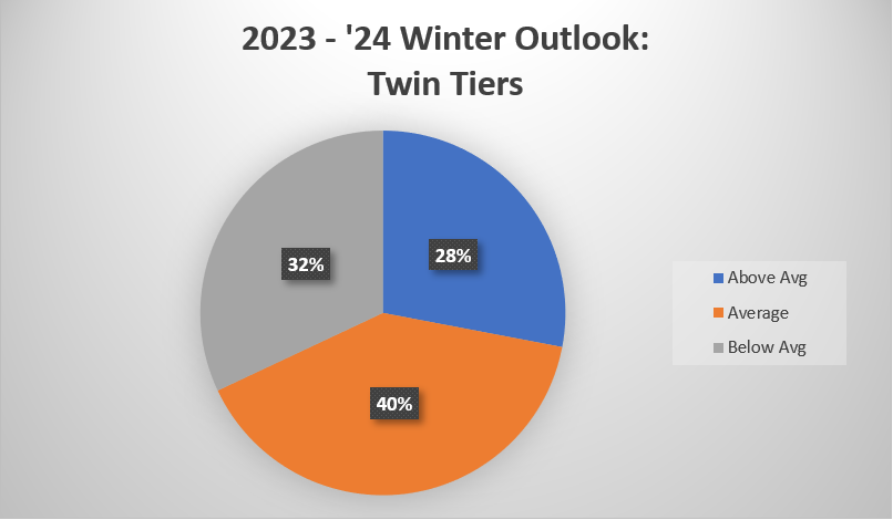
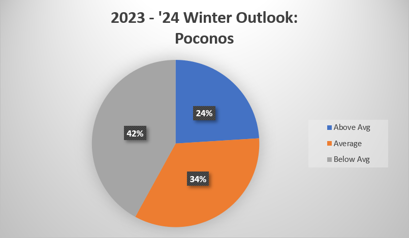
Above is our initial winter outlook for the upcoming season, which shows a general favorability for average snowfall for the Twin Tiers of Pennsylvania and New York. Farther east towards Scranton, and more particularly, Stroudsburg, PA below average snowfall is slightly favored.
Looking Ahead…
As we now enter the mid-section of the month, November has been fairly normal with a handful of cold nights in the 20’s °F and some warmer days in the 50’s and even 60’s °F. Through the coming week we’ll continue to see the pendulum swing with temperatures fluctuating above and then below average. There are, however, hints for a pattern change coming across the Central and Eastern U.S. in the days leading up to Thanksgiving, bringing potential for more persistent cold weather and lake effect snows.
With cold air bottling up in the heart of the country as we close out November, chances are that one of these storm systems may line up to give us our first measurable snowfall in the Twin Tiers. Towards the Finger Lakes and even out in central & western PA, many have already seen the snow fly and they will certainly be in the most favorable spot to see it again. Beyond that, could a warm up in December be looming as the influences of El Niño take ahold? Only time will tell.
Interesting and very informative, thanks
Great piece of information! forecasting weather can be fascinating to say the least so many variables involved thank you for shedding some light on some of that.