Heat of The Moment
It would appear that Mother Nature is confused, or at least has us all confused. Local critters can be found taking a break from hibernation while the geese are seen heading back north. Trees are beginning to bud, sprouts are emerging from the ground, and the maple sap is flowing. But is anyone really complaining? Temperatures in the 50’s and 60’s this past week have not only turned up our mood but have allowed us to turn down the heat putting savings back into our pockets as we spring through the heart of the winter relatively unscathed.

Up through the mid-point of February, temperatures have averaged around five degrees above normal keeping the warm winter trend rolling from January’s nine degree temperature departure, which is well above normal! In fact, January’s average temperature is the warmest on record in the last 30 years with February currently on pace to see the least amount of snowfall since 2002. Might this trend continue?
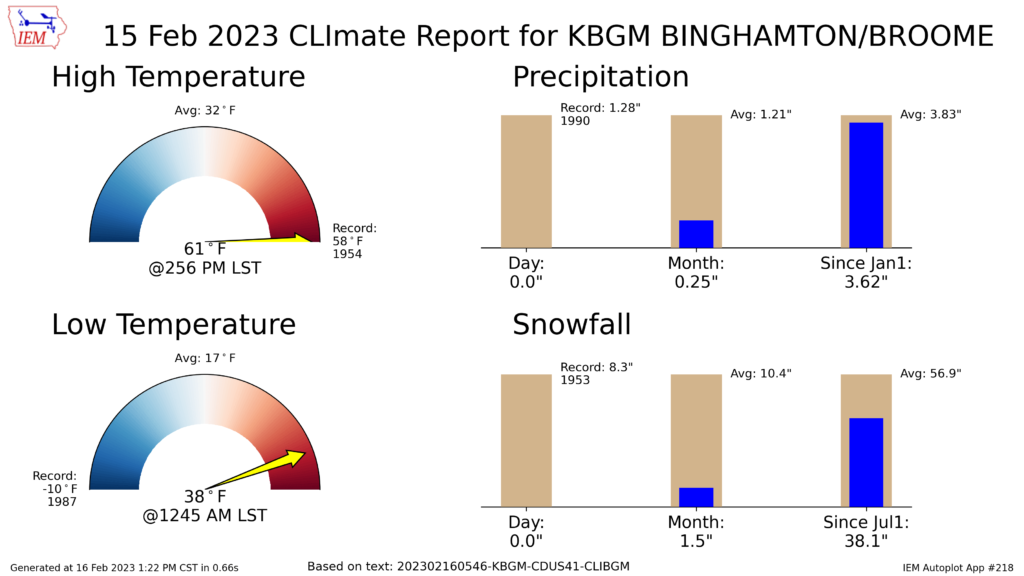
Temperature records were broken across the Northeast on February 15th with Binghamton airport reaching 61F, beating the original record of 58F set back in 1954. Williamsport’s airport saw record heat as well setting the bar at 72F, which smashed their record of 60F from 1949. And as you can see (below) we are in quite the snow deficit with only 1.5″ of snow reported so far this month, running nearly 20 inches behind the seasonal average.
The Winter Sun
Typically this time of year the grounds are still frozen with at least a few piles of snow sitting in our yard and a measurable snowpack visible along the snowbelt region (near the Great Lakes). The rays from the winter sun reflect efficiently off the white snow and icy lakes, sending the sun’s energy back in the atmosphere and thus having a lesser influence on our daily temperature. Unfortunately for this winter, that’s not the case.
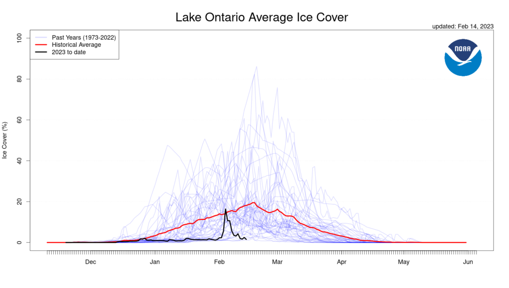
No snow-pack means the Earth is effectively capturing the incoming rays on sunny days, pushing temperatures above the climatological norm. It also doesn’t help that ice cover is at an all time minimum across the Great Lakes and Finger Lakes at a time when we should be approaching peak coverage. According to Environmental Canada’s Canadian Ice Service, this winter set an all time record low at just 8% ice coverage across the Great Lakes, well below last year’s 51% and historical median of 30%.
You may have also noticed the later days returning as sunset inches closer to the 6 o’clock hour, with sunrise now approaching 7AM. The increasing sunlight is a welcoming gesture of Spring signaling winter’s final weeks. In fact, the solar angle is now equivalent to that of late October, meaning the sun will begin to have a greater influence on accumulating snowfall during the daytime as it’s melting power continues to increase.
In and Out Like A Lamb
With all this talk of warm weather it’s hard to imagine that winter has a chance to come back from such a deficit. Even the geese think winter is over! With no snowpack and unfrozen grounds, cold air may be hard to come by and even when it does, it doesn’t stick around. So what seems to be the issue?
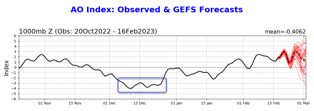
The majority of this winter has been governed by two dominate weather features. One is found in the Arctic Oscillation (AO), which provides us a way to measure the state of the atmospheric circulation over the Arctic. In a negative phase we would see bouts of artic air infiltrating the Lower 48 with at least some mention of the “Polar Vortex” hitting the mainstream media. Aside from the brief arctic blast we saw at the end of 2022 (indicated in the blue box on the graphic below), the AO has mostly held in the neutral or positive phase through the start of 2023 and is forecast to continue that way into early March. In layman’s terms, cold air may only be available in small doses.
Another piece of the puzzle lies in the northern Pacific Ocean. The PNA or Pacific-North American index is one of the most recognized climate influencers in the Northern Hemisphere, particularly here in the United States. This index is forecast to hold in the negative phase into early March indicating higher pressure and generally above average temperatures across the Eastern U.S.. Overall with these two pieces in place, the beginning of March doesn’t look overly promising for snow lovers.
With that said, we are expecting a bit of a cool down toward next weekend around February 24th, which may open the door to some winter weather with near (or closer to) average temperatures heading into early March. Some indicators claim the mid-section of next month may again bring colder weather and perhaps a chance at a brief winter comeback, but it’s been the same song and dance most of the winter with these long range forecasts. All tease and no delivery.
It may be safe to throw out the old wives tale “in like a lion, out like a lamb” as this winter has been nothing but a whimper when compared to years past. But it is still only February after all with nor’easter season just around the corner. Let’s just hope the budding trees don’t end up paying for their early arrival as winter tries to sneak in one last gasp.
Outstanding read!
Outstanding read!
Thank you sir! Appreciate you taking the time to read through it.