January Thaw
With an early arrival of ‘mud season’ in the Northeast, one can’t help but wonder where winter went or if it even truly arrived. Following the relentless cold of this past Christmas and -20F degree wind chills, our taste of winter was short lived as record breaking warmth hit thermometers across the Twin Tiers during the last days of 2022.
Even after turning the calendar into 2023, this weather might have you convinced that it’s already spring! Temperatures for the first week of January ran nearly 15 to 20 degrees above normal, leaving no chance for snow to make a return. Now here we are heading into the mid-section of the month with autumn’s leaves scattered about and birds wondering which direction they should fly. So is this a sign of what’s to come? Has winter already thrown in the towel and called it quits?
Trouble in the Pacific
Before we dive too deep into the rabbit hole, it’s important to identify the true drivers of the current weather pattern to get a better understanding of where things are going. Over the last week, drought-stricken California has been receiving what seems like a whole season’s worth of rain within a matter of days, and the rain is only forecast to continue. And who else is there to blame but the atmospheric river of moisture being lofted in by what has been an extremely active Pacific jet stream.
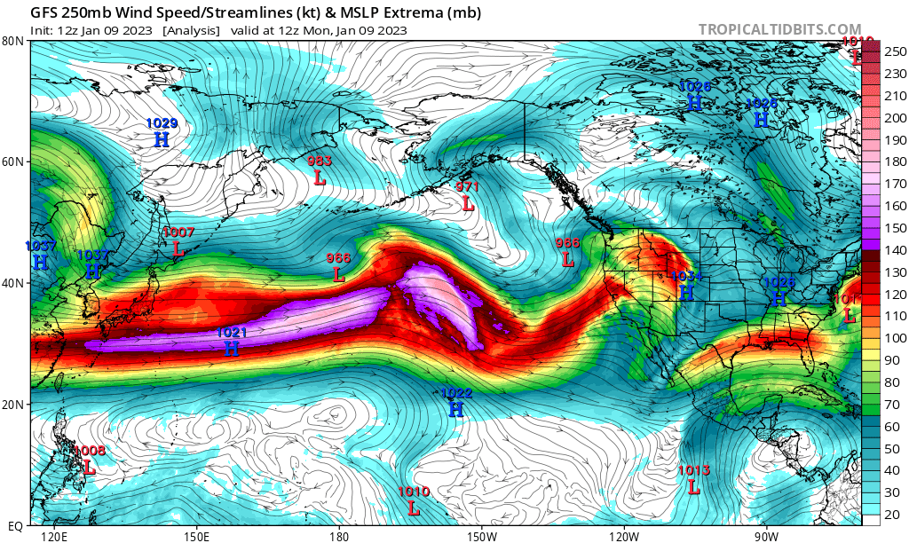
From the image above, one can’t help but notice the reds and purples over the Pacific Ocean, indicating high speed, upper-level winds where the jet stream exists. These persistent jet stream winds have been the main driver in the California floods but have also played a big part in the weather on the East Coast. It’s hard to believe something so far away could have lasting affects right here at home, but it’s true. Some say the “Pacific (pattern) is King”, and without a large-scale intrusion near the Gulf of Alaska to buckle the jet stream, these mild conditions might just continue.
So you’re Telling Me There’s a Chance?
Temperatures early this week will generally float just above average with highs in the mid-30’s to near 40F only to surge further into the 40’s as the next storm system arrives Thursday into Friday. For snow lovers this probably isn’t your type of weather with about a half inch of rain in the forecast, but what if I told you that there’s a chance for winter to make a brief return this weekend?
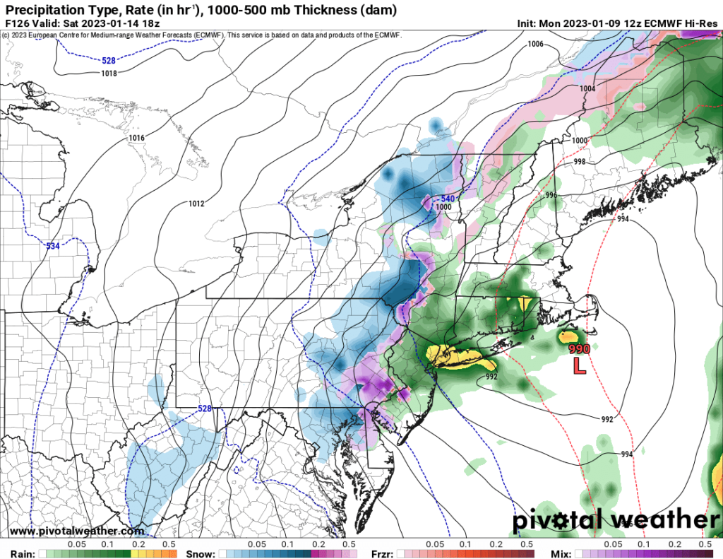
As mentioned in the previous section, we’re in need of a storm system near the Gulf of Alaska to break the Pacific pattern, and weather models are showing just that. The buckling of the jet stream later this week is expected to send a shot of cold air down from Canada and into the Northeast, giving us a thread-the-needle type scenario for some accumulating snow in places that have yet to see the white stuff.
Latest runs from the global weather models like the ECMWF or ‘Euro’ for short, are picking up on the development of a low near coastal New England early Saturday, which may have just enough upper-level support to wrap in some snow on the backside of the system. Although it’s too early to really put any money down for places like Philly and DC to see accumulations, it bares watching for those in the snow business as workable snowfall has been hard to come by this season.
All it Takes is One Storm
While this weekend’s storm will be far from the highlight of the season, it really only takes one large event to get us back on track. Currently snowfall departures are running about nine inches or so behind the seasonal average (for the lower elevations across the Twin Tiers). So in all reality, it would only take one good snowfall to make this seamlessly “dry” winter a good one. That and we’ll need some colder weather.
But that’s just it – where’s the cold? Even with a return of near normal conditions heading into the middle of the month, it appears this cool down will again be short lived. As the Pacific jet stream sets back up to bring more rain to the West Coast next week, the East Coast will likely see a return of above normal temperatures after the 17th meaning more rain and perhaps some mixed precipitation events.
Snow in the Crystal Ball
With all this talk of warm weather, we come back to our original question, “has winter been canceled”? Well, it may seem that for January Old Man Winter may not be making a true showing, but there’s still February and March or as I like to refer to as nor’easter season! With a little nudge in the right direction and perhaps some help from the Arctic, there’s still plenty of time to pray for snow.
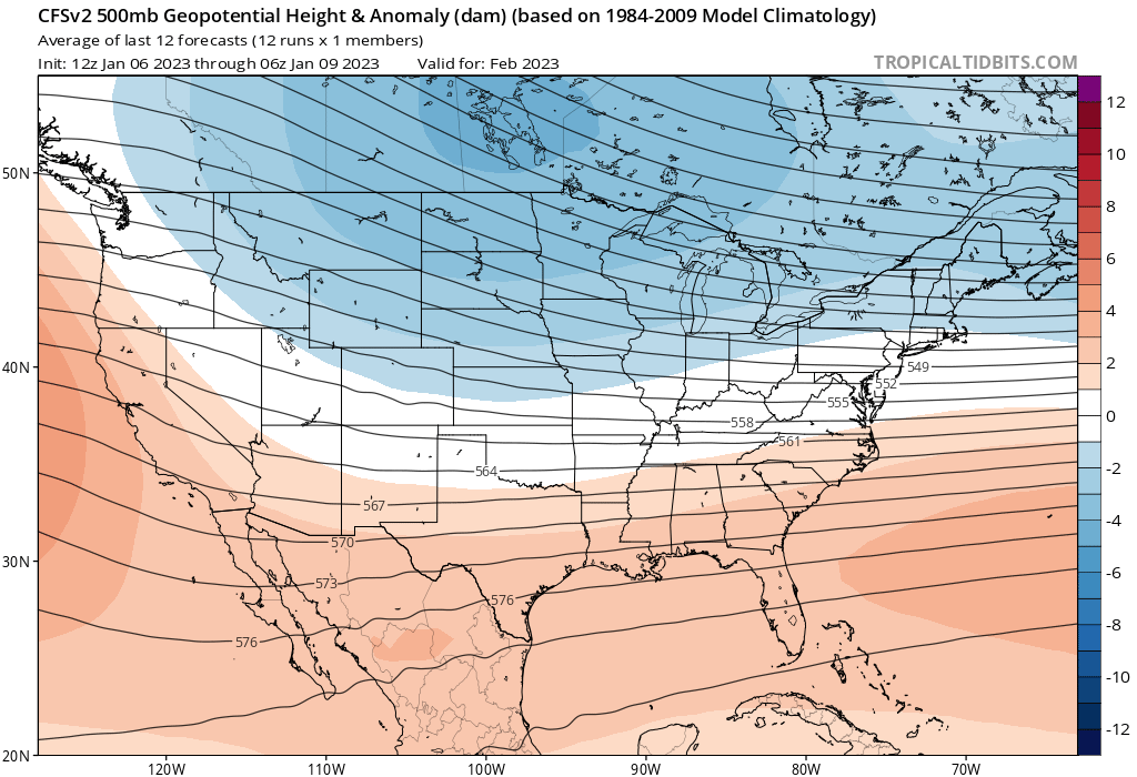
Long range guidance from the Climate Forecast System (CFS) is hinting that February may turn active and snowy for the Northern Plains and Upper Midwest. For us here in the mid-Atlantic, we’re likely more of a battle ground between warm, moist airmasses from the south and cold, dry air to the north. This is good for those that want to see more opportunities for winter weather next month, but could also mean the threat of mixed events or ice! Not to mention with the Great Lakes still far from frozen, more lake effect snow is also on the horizon.
Currently with a strong Polar Vortex (PV) in place around the North Pole, all the cold air is bottled up near the Arctic Circle, hence the lack of it down here in the mid-latitudes. But just like with our example of the Pacific jet stream, it’s only a matter of time before we see disturbances buckle the circulation (of the PV), which would then open up the door to those freezing temperatures and a true return to winter.
Like it or not, the warmer weather I’m sure has helped those struggling with heating bills with record prices.
That’s for sure. Europe has also been seeing a warmer than normal winter this year, which is good considering the energy crises ongoing out there.
Amen to that.
So far so good. I know eventually some true winter depravity will occur but each day the sun gets a little closer to us now and the length of time winter can persist decreases!